


The next CEF/CEABN Seminar – Brazil Data Cube: satellite image data cubes and time series analysis for land use and land cover mapping – will take place on April 30, from 12:30 p.m. to 1:30 p.m., in the Salão Nobre of the Instituto Superior de Agronomia.
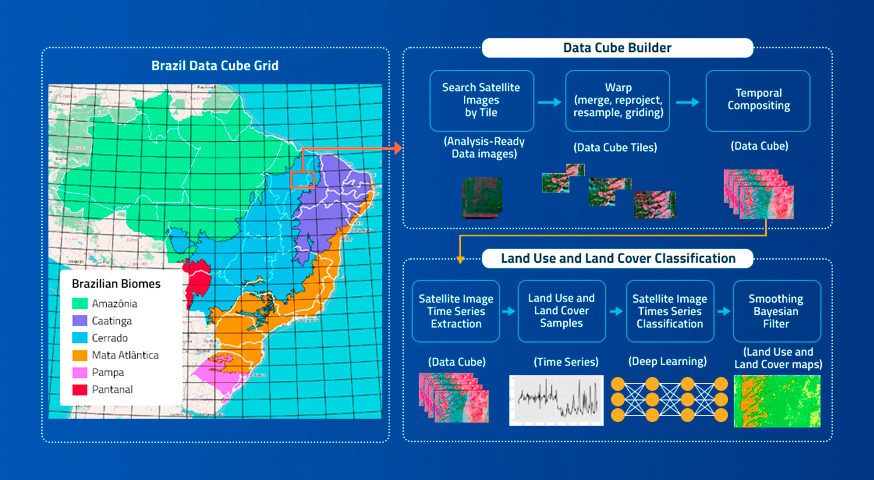
This edition of the CEF/CEABN Seminars features a presentation by PhD Researcher Karine Ferreira on the Brazil Data Cube project, a research, development and technological innovation project of the National Institute for Space Research (INPE), Brazil. It is producing data sets from big volumes of medium-resolution remote sensing images for the entire national territory and developing a computational platform to process and analyze these data sets using artificial intelligence, machine learning and image time series analysis.
Karine Ferreira is PhD in Applied Computing and works at the Brazilian National Institute for Space Research (INPE), with research and development in Geoinformatics, coordinating innovative projects in this area such as TerraBrasilis and Brazil Data Cube. She is the head of the Earth Observation and Geoinformatics Division at INPE. She is professor of the Postgraduate Course in Applied Computing at INPE and her main research line is representation, processing and analysis of spatiotemporal and big Earth observation data, focusing on satellite image time series analysis.