Notícias
Publicações
Artigos Científicos (ISI)
Abate D., Botequim B., Marques S., Lagoa C., Hernández J. G., Hengeveld G., Hoogstra-Klein M., Borges J.G. (2025)
Recreational and Aesthetic Values of Forest Landscapes (RAFL): Quantifying management impacts and trade-offs with provisioning and regulatory ecosystem services
Forest Ecosystems. DOI: https://doi.org/10.1016/j.fecs.2025.100318
Magalhães J.A., Guerra-Hernández J., Cosenza D. N., Marques S., Borges J.G., Tomé M. (2024)
Development of a Methodology Based on ALS Data and Diameter Distribution Simulation to Characterize Management Units at Tree Level
Remote Sens., 16(22), 4238 . DOI: https://doi.org/10.3390/rs16224238
Pascual A., Guerra-Hernandez J. (2023)
Correction of phenology-induced effects in forest canopy height models based on airborne laser scanning data. Insights from the deciduous mountain forests in Picos de Europa National Park in Spain
Ecological Informatics, 75: 102092. DOI: https://doi.org/10.1016/j.ecoinf.2023.102092
Pascual A., Guerra-Hernandez J., Armston J., Minor D.M., Duncanson L.I., May P.B., Kellner J.R., Dubayah R. (2023)
Assessing the performance of NASA’s GEDI L4A footprint aboveground biomass density models using National Forest Inventory and airborne laser scanning data in Mediterranean forest ecosystems
Forest Ecology and Management, 538: 120975. DOI: https://doi.org/10.1016/j.foreco.2023.120975
Tupinambá-Simões F., Pascual A., Guerra-Hernández J., Ordóñez C., de Conto T., Bravo F (2023)
Assessing the performance of a handheld laser scanning system for individual tree mapping—a mixed forests showcase in Spain
Remote Sensing, 15(5): 1169. DOI: https://doi.org/10.3390/rs15051169
Guerra-Hernández J., Botequim B., Bujan S., Jurado-Varela A., Molina-Valero J.A., Martínez-Calvo A., Pérez-Cruzado C. (2022)
Interpreting the uncertainty of model-based and design-based estimation in downscaling estimates from NFI data: a case-study in Extremadura (Spain).
GIScience and Remote Sensing, 59 (1): 686-704. DOI: https://doi.org/10.1080/15481603.2022.2051383
Guerra-Hernandez J., Narine L.L., Pascual A., Gonzalez-Ferreiro E., Botequim B., Malambo L., Neuenschwander A., Popescu S.C., Godinho S. (2022)
Aboveground biomass mapping by integrating ICESat-2, SENTINEL-1, SENTINEL-2, ALOS2/PALSAR2, and topographic information in Mediterranean forests
Giscience & Remote Sensing, 59(1): 1509-1533. DOI: https://doi.org/10.1080/15481603.2022.2115599
Pascual A., Guerra-Hernández J. (2022)
Spatial connectivity in tree-level decision-support models using mathematical optimization and individual tree mapping
Forest Policy and Economics, 139: 102732. DOI: https://doi.org/10.1016/j.forpol.2022.102732
Pascual A., Tupinambá-Simões F., Guerra-Hernández J., Bravo F. (2022)
High-resolution planet satellite imagery and multi-temporal surveys to predict risk of tree mortality in tropical eucalypt forestry.
Journal of Environmental Management, 310: 114804. . DOI: https://doi.org/10.1016/j.jenvman.2022.114804
Pascual A., Tupinambá-Simões F., Guerra-Hernández J., Bravo F. (2022)
High-resolution planet satellite imagery and multi-temporal surveys to predict risk of tree mortality in tropical eucalypt forestry
Journal of Environmental Management, 310: 114804. DOI: https://doi.org/10.1016/j.jenvman.2022.114804
Tupinambá-Simões F., Bravo F., Guerra-Hernández J., Pascual A. (2022)
Assessment of drought effects on survival and growth dynamics in eucalypt commercial forestry using remote sensing photogrammetry. A showcase in Mato Grosso, Brazil.
Forest Ecology and Management, 505: 119930.. DOI: https://doi.org/10.1016/j.foreco.2021.119930.
Tupinambá-Simões F., Bravo F., Guerra-Hernández J., Pascual A. (2022)
Assessment of drought effects on survival and growth dynamics in eucalypt commercial forestry using remote sensing photogrammetry. A showcase in Mato Grosso, Brazil
Forest Ecology and Management, 505: 119930. DOI: https://doi.org/10.1016/j.foreco.2021.119930
Alonso-Rego C., Arellano-Pérez S., Guerra-Hernández J., Molina-Valero J.A., Martínez-Calvo A., Pérez-Cruzado C., Castedo-Dorado F., González-Ferreiro E., Álvarez-González J.G., Ruiz-González A.D. (2021)
Estimating stand and fire-related surface and canopy fuel variables in pine stands using low-density airborne and single-scan terrestrial laser scanning data
Remote Sensing, 13(24):5170. DOI: https://doi.org/10.3390/rs13245170
Bujan S., Guerra-Hernández J., Gonzalez-Ferreiro E., Miranda D. (2021)
Forest road detection using LiDAR data and hybrid classification
Remote Sensing, 13(3): 393. DOI: https://doi.org/10.3390/rs13030393
Dorado-Roda I., Pascual A., Godinho S., Silva C.A., Botequim B., Rodríguez-Gonzálvez P., González-Ferreiro E., Guerra-Hernández J. (2021)
Assessing the accuracy of GEDI data for canopy height and aboveground biomass estimates in Mediterranean forests
Remote Sensing, 13(12):2279. DOI: https://doi.org/10.3390/rs13122279
Guerra-Hernández J., Arellano-Perez S., Gonzalez-Ferreiro E., Pascual A., Altelarrea V.S., Ruiz-Gonzalez A.D., Alvarez-Gonzalez J.G. (2021)
Developing a site index model for P. Pinaster stands in NW Spain by combining bi-temporal ALS data and environmental data
Forest Ecology and Management, 481: 118690. DOI: https://doi.org/10.1016/j.foreco.2020.118690
Guerra-Hernández J., Díaz-Varela R.A., Ávarez-González J.G., Rodríguez-González P.M. (2021)
Assessing a novel modelling approach with high resolution UAV imagery for monitoring health status in priority riparian forests
Forest Ecosystems, 8(1): 61. DOI: https://doi.org/10.1186/s40663-021-00342-8
Guerra-Hernández J., Pascual A. (2021)
Using GEDI lidar data and airborne laser scanning to assess height growth dynamics in fast-growing species: a showcase in Spain
Forest Ecosystem, 8: 14. DOI: https://doi.org/10.1186/s40663-021-00291-2
Pascual A., Guerra-Hernández J., Cosenza D.N., Sandoval-Altelarrea V. (2021)
Using enhanced data co-registration to update Spanish National Forest Inventories (NFI) and to reduce training data under LiDAR-assisted inference
International Journal of Remote Sensing, 42(1), 126-147. DOI: https://doi.org/10.1080/01431161.2020.1813346
Cosenza D.N., Pereira L.G., Guerra-Hernández J., Pascual A., Soares P., Tomé M. (2020)
Impact of calibrating filtering algorithms on the quality of Lidar-derived DTM and on forest attribute estimation through area-based approach
Remote Sensing, 12(6): 918. DOI: https://doi.org/10.3390/rs12060918
Leite R.V., Silva C.A., Mohan M., Cardil A., de Almeida D.R.A., Carvalho S.D.C.E., Jaafar W.S.W.M., Guerra-Hernández J., Weiskittel A., Hudak A.T., Broadbent E.N., Prata G., Valbuena R., Leite H.G., Taquetti M.F., Soares A.A.V., Scolforo H.F., do Amaral C.H., Dalla Corte A.P., Klauberg C. (2020)
Individual tree attribute estimation and uniformity assessment in fast-growing Eucalyptus spp. Forest plantations using lidar and linear mixed-effects models
REMOTE SENSING, 12(21): 3599. DOI: https://doi.org/10.3390/rs12213599
Pascual A., Guerra-Hernández J., Cosenza D.N., Sandoval V. (2020)
The role of improved ground positioning and forest structural complexity when performing forest inventory using airborne laser scanning
Remote Sensing, 12(3): 413. DOI: https://doi.org/10.3390/rs12030413
Cosenza D.N., Soares P., Guerra-Hernández J., Pereira L., González-Ferreiro E., Castedo-Dorado F., Tomé M. (2019)
Comparing Johnson’s SB and weibull functions to model the diameter distribution of forest plantations through ALS data
Remote Sensing, 11(23): 2792.
Guerra-Hernández J., Cosenza D.N., Cardil A., Silva C.A., Botequim B., Soares P., Silva M., González-Ferreiro E., Díaz-Varela R.A. (2019)
Predicting growing stock volume of Eucalyptus plantations using 3-D point clouds derived from UAV imagery and ALS data
Forests, 10(10): 905. DOI: https://doi.org/10.3390/f10100905
Guerra-Hernández J., Cozenza D.N., Rodriguez L.C.E., Silva M., Tomé M., Díaz-Varela R.A., González-Ferreiro E. (2018)
Comparison of ALS- and UAV (SfM)-derived high-density point clouds for individual tree detection in Eucalyptus plantations
International Journal of Remote Sensing, 39(15-16): 5211-5235. DOI: https://doi.org/10.1080/01431161.2018.1486519
Guerra-Hernández J., González-Ferreiro E., Monleón V. J., Faias S.P., Tomé M., Díaz-Varela R. A. (2017)
Use of Multi-Temporal UAV-Derived Imagery for estimating individual tree growth in Pinus pinea stands
Forests, 8(8): 300.
Guerra-Hernández J., González-Ferreiro E., Sarmento A., Silva J., Nunes A., Correia A., Fontes L., Tomé M., Díaz-Varela R. (2016)
Using high resolution UAV imagery to estimate tree variables in Pinus pinea plantation in Portugal
Forest Systems, 25(2): eSC09.
Guerra-Hernández J., Görgens E., García Gutiérrez J., Rodriguez, L.C.E., Tomé M., González-Ferreiro E. (2016)
Comparison of ALS based models for estimating aboveground biomass in three types of Mediterranean forest
European Journal of Remote Sensing, 49: 185-204.
Guerra-Hernández J., Tomé M., Gonzalez-Ferreiro E. (2016)
Using low density LiDAR data to map Mediterranean forest characteristics by means of an area-based approach and height threshold analysis
Revista de Teledetección, 46: 103-117.
Livros
Capítulos de Livros
Borges J.G., Garcia-Gonzalo J., Guerra-Hernandez J., Marques S., Palma J.H.N. (2013)
Chapter IX. A decision support system for forest management planning under climate change
In: Adapting to climate change in European forests – results of the MOTIVE Project. J. Fitzgerald and M. Linder (Eds.). Pensoft, pp. 89-92.. URL: http://motive.pensoft.net/NPDOCS/MOTIVE2_FINAL_FULL.pdf
Projetos
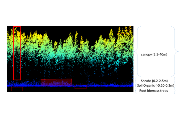
BLS-BIOMASS
Below, Litter & Shrub BIOMASS density mapping combining optical, LiDAR and SAR Earth Observation data
Duração: 2024-2026
Orçamento CEF: 71.488 € €
CorkNut
Florestas mistas de sobreiro e pinheiro manso: Gestão para valorização dos produtos, promoção da biodiversidade e prevenção de fogos florestais
Duração: 2021-2025
Orçamento CEF: 163640.00 €
SUFORUN
Models and decision SUpport tools for integrated FOrest policy development under global change and associated Risk and UNcertainty
Duração: 2016-2020
Orçamento CEF: 275333.00 €
