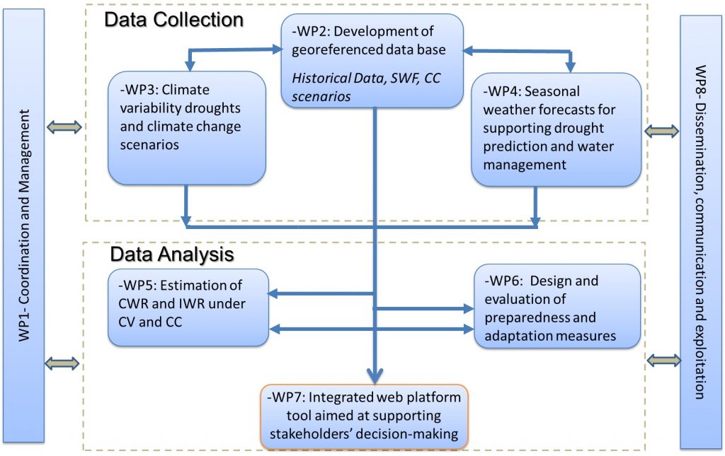
The project integrates eight (8) tasks as per the figure below. Tasks devoted to management (Task 1) and to Dissemination, communication and exploitation are not described herein. The project tasks are the following:
Task 2 – Development of the geo-referenced database
A database will be built for continental Portugal, which will include georeferenced data relative to weather, soil, groundwater table depths, cropping systems and irrigation systems.
Task 3 – Climate variability, droughts and climate change scenarios
This task will focus on the study of changes in climate variability and the frequency, intensity, spatial extent, duration, and timing of droughts. The assessment will focus on the annual and interannual precipitation variability at diverse scales, including the main spatial patterns of the different drought indicators (SPI, PDSI and MedPDSI). The MedPDSI tool was already developed and tested in Portugal and presents clear advantages relative to the most used tools, mostly because it is adapted to the Mediterranean conditions, using the olive crop instead of the original winter wheat (PDSI) for computing the actual crop ET, and the potential ET bases upon the FAO dual Kc-ETo approach. MedPDSI will allow detecting soil water anomalies that could be related to drought and could produce information useful for supporting farmers’ decision making. A tool was already developed for each of the selected indices. All the drought indicators will be computed at diverse time scales of 1, 3, 6 and 12 months allowing monitoring of droughts. The already identified homogeneous regions, in terms of rainfall and droughts, in the country will be used to support regional analysis.
Another way to assess climate variability is the development of Agro-productivity zones (high, medium, low) based on microclimatic and soil features. The proposed methodology is based on EO data and methods (e.g. Landsat-8, Sentinel-2) which has been successfully applied to vineyards in Portugal.
This Task will also include the correction and downscaling of climate change scenarios from the Regional Climate Models (RCMs) outputs produced by the ENSEMBLES project (EC-FP6-ENV).
Task 4 – Seasonal weather forecasts for supporting drought prediction and water management
This task will first focus on the assessment of the reliability of the SWF ensemble using a historical set of hindcasts. Forecasts are inherently uncertain, and this uncertainty will be quantified by issuing probability statements about future observable outcomes based on current and past forecasts and observations.
Direct and indirect assessment will be performed with the latter being performed by comparing CWR estimated using observed daily weather data and those estimated using different time scales hindcasts (1, 3 and 6 months).
In the following, aiming at coping with climate variability and drought in advance of the season, the SWF information will be ingested in the developed PDSI and MedPDSI tools (Task 3). The use of SWF with these drought tools will allow the design of preparedness and adaptation measures (Task 6).
Task 5 – Estimation of crop water and irrigation water requirements under climate variability and climate change conditions
The SWB model SIMDualKc, which has already been calibrated and validated for diverse annual crops and orchards in Portugal and abroad, is selected for this project. To support the operational mapping and upscaling of the crop water and irrigation requirements, the model will be coupled with CGM and EO data in a GIS-based approach (Task 2); the EO data ingestion will allow improving the timely accuracy of the computations. This will allow enlarging the actual available data to the various climate conditions of continental Portugal, including under drought conditions. The use of the SWF (Task 4) will allow supporting the predictability of drought and of water and irrigation water requirements in advance in the season. Thus, allowing to support decision making in advance in the season. This is particularly important for Water Users Association and farmers.
The climate change scenarios (Task 3) will be used with the SWB model for estimating the water and irrigation requirements under those weather conditions and maps will be produced.
Moreover, the data and maps will be made available in the project platform to be usable by the various users from farmers to irrigation project managers, and basin authorities (Task 7). The support of water users’ associations and growers’ associations will foster knowledge transferability (Task 8).
Task 6 – Design and evaluation of preparedness and adaptation measures
Main field crops in Portugal will be selected for the assessment of several management scenarios. The project will focus on annual crops that are usually rainfed and that under drought conditions may require supplemental irrigation, and fully irrigated ones. Specific management scenarios will be built for orchards and vineyards and will mainly focus on irrigation scheduling strategies.
For annual crops, management scenarios will include sowing dates (anticipation or delay) and irrigation scheduling alternatives, including deficit and supplemental irrigation as adaptive measures to be used when drought is predicted (Task 4). These scenarios will be the first run at field scale and then upscaled to watershed, regional and country level. Other practices will be designed, using the participation of the Advisory Committee and evaluated considering the local conditions and therefore ensuring their sustainability.
Maps showing the probability of exceeding median CWR and yield for each crop will be produced with predictions starting at the beginning of the growing season, with updates each month as the season advances.
The impacts/benefits of the different alternatives will be assessed in economic (production, income and economic water productivity) and environmental (water and carbon footprints) terms. The water footprint will include the determination of the green, blue and grey waters. Since energy plays an increasing role in determining water resources allocation and use, the study also focuses on the computation of the crop’s energy balance and related indicators (e.g. energy efficiency) of the diverse scenarios.
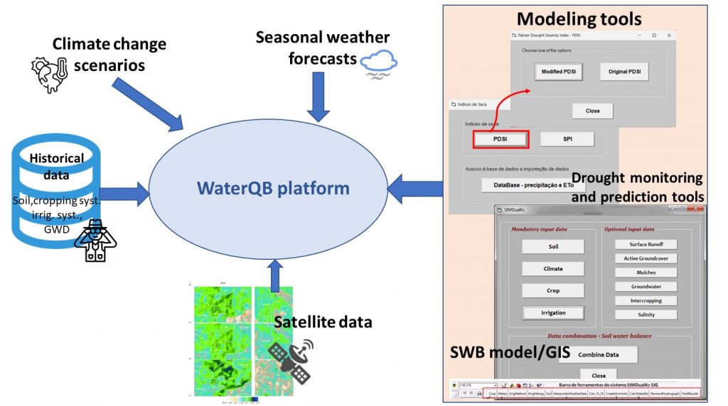
Task 7 – Integrated web platform tool aimed at supporting stakeholders’ decision-making
The WaterQB integrated platform tool is GIS-based modelling and DSS. Main data sorts for upload and visualization on the DSS are GIS layer (administrative and cadastral boundaries, soils types, irrigation systems, water bodies, etc), EO images and derived information products (maps of cropping systems, fraction of ground covered by the crops, soil moisture at the root zone), model output (e.g., SIMDualKc spatialized crop water and irrigation requirements for the upcoming season and for high climatic demand conditions, predicted drought indices, estimated yield, preparedness measurements and related cost-benefits analysis).
The platform DSS will receive information from the preceding Tasks thus, from multiple sources, will process and diffuse them back to diverse users/stakeholders via the web interface.
Outputs of the tools consist of quantitative estimation and the spatial mapping of the crop water and irrigation requirements in advance in the season allowing to support stakeholders’ decision making.
The platform will not be a static tool, but it is envisioned that it would evolve in time, through research, and with updated insights. As an output, this task will deliver a tailored and relevant framework and design principles for the present and future development of an envisioned National Information Service.